Monday, August 28, 2006
Monday, August 21, 2006
Reservoir
We have disovered this brick, circular water storage reservoir beneath early (eighteenth century) buildings on the Wednesbury Forge site.
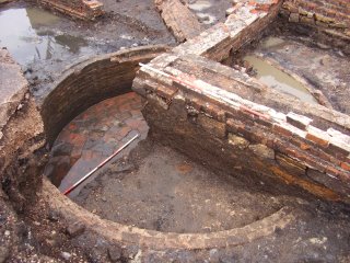 View of the half-sectioned feature.
Our excavations are now nearing their end. However we will return in a couple of weeks to further explore the area of the 'windmill' and associated features. The aim will be to sample below the eighteenth century features to see if the tantalising remains of earlier structures do indeed survive.
Thursday, August 17, 2006
Ditherington Flax Mill
We have been back at Ditherington again this month, monitoring the excavation of foundation holes on behalf of English Heritage. This work has certainly provided an interesting insight into the construction of this famous iron-framed building. Many of the first set of holes showed quite minimal foundations. Minimal foundations is not perhaps surprising in itself for an eighteenth century building, but more interesting is the variability of the foundation levels and the range of different approaches to construction.
The purpose of these holes is to provide support for temporary scaffolding which will be erected by English Heritage whilst a more permanent solution for improving the structural integrity of the building can be found.
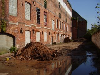 Exterior holes being dug on the SE side of the mill.
 General view of the interior columns with holes to take line-shafting.
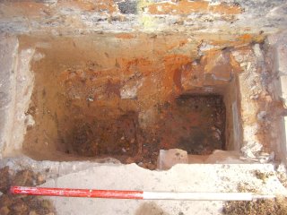 Hole No.24.
 The 18th hole! Hole No.18, showing drainage culvert.
The purpose of these holes is to provide support for temporary scaffolding which will be erected by English Heritage whilst a more permanent solution for improving the structural integrity of the building can be found.
 Exterior holes being dug on the SE side of the mill.
 General view of the interior columns with holes to take line-shafting.
 Hole No.24.
 The 18th hole! Hole No.18, showing drainage culvert.
Friday, August 11, 2006
Hearths and Drains
The excavation at Wednesbury has now entered its final phase, and we are exploring the area which was first revealed by evaluation Trench 6. The area in the foreground of this photo was part of the trench, we have now opened up a wider area beyond it including the main road through site. Although truncated by drains and culverts, this part of the site seems to have contained a large number of small hearths - which we presume at this stage were for hand-forging and the finishing of goods.
 View looking west on Wednesday. The machine is breaking up the concrete road surface.
 View looking west on Wednesday. The machine is breaking up the concrete road surface.
Friday, August 04, 2006
Jackfield Revisited
Work at Jackfield is now in its final stages and the archaeological aspects of the project are now more or less complete. However during the final stage of works at the eastern end of the site the contractors have uncovered a series of early yard surfaces which we have been busy recording. These are located between the Clay Arcs and the Mill Building.
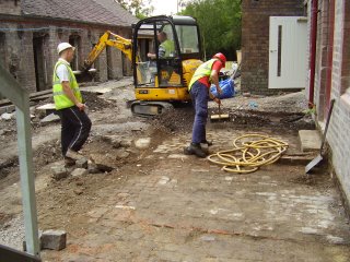 Granite setts, brick paving and even some wall foundations are being uncovered.
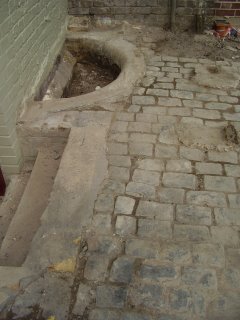 Some of the features are nicely detailed, such as this semi-circular drain sump which is edged with rounded brick.
We hope to be able to preserve some of these for future visitors to see. Other bits may survive beneath the modern paving, where they will be protected by a layer of sand before the new surface is laid.
 Granite setts, brick paving and even some wall foundations are being uncovered.
 Some of the features are nicely detailed, such as this semi-circular drain sump which is edged with rounded brick.
We hope to be able to preserve some of these for future visitors to see. Other bits may survive beneath the modern paving, where they will be protected by a layer of sand before the new surface is laid.
Wednesday, August 02, 2006
The 'Lloyds' Road
Work will start in September on realignment of this section of the The Lloyds - the road which runs from the Jackfield Bridge towards Coalport. This section of the road is very badly affected by mining subsidence. The main item of archaeological interest will be the wall of slag blocks which currently lines the road.
 View looking west along the affected section.
The remdedial scheme will involve deep piling along both sides of the road. Some archaeological recording will be required before and during the work. The scheme has been devised by Telford and Wrekin Council but a contractor has yet to be appointed.
 View looking west along the affected section.
The remdedial scheme will involve deep piling along both sides of the road. Some archaeological recording will be required before and during the work. The scheme has been devised by Telford and Wrekin Council but a contractor has yet to be appointed.

